TGOC 2018 Days 11 to 14 (Mon 21st to Thu 24th) - Glenshee to Kinnaber Links
It had been blue skies most of the way, so ONLY far that the final music should be
Gary Hoey - Fade to Blue
Just 4 more days to go, but there were still adventures to be had OH YES.
Day 11 - Mon 21st Glenshee to Craig Tillelet (Glen Prosen) - (19 km)
Up at the usual hour, watered and cleaned and fed, and laden with new parcel of heavy food, we headed out.
Phil dropped off the key, and we made our way across the fields following yet another non existent OS track over ground that at the best was damp, and at the not so bad bloody wet, down to the wee lochan via a herd of cows that I thought Al may not manage to navigate.
Cows, and bridges with no sides are not his thing.
How the heck he has got across Scotland 23 official times (corrected) , let alone Le Jog and Lord knows how many other trips I don't know. A legend in his own opinion 🤣 and a good friend.. 😊
 |
| Loch Beanie |
 |
| Al consuming grams |
We paused for a rest, I took some pictures and aired feet, and then we moved on along the side of the loch (it was bloody wet) and up and over a small climb to drop down into and along Glen Beanie
Another track / no track sort of hill until we eventually got to the track just past the forestry clearance. There was a machine up on the hill side plucking and shredding trees like they were match sticks.
At the end we picked up the road just past the estate buildings at Dalvanie.
We carried on along the road up Glen Isla until we reached Fergus. I say carried on, we had a 10 min stop, could have been longer (I think it was here ???) The weather was fine, and Al I think at this point needed to climb over a wall for some reason.
We had a chat with a chap near Dalnamer, who had seen us earlier, and then headed up the track and over the bridge to start the long climb up to Craig Lair
I collected some water on route before the small hut, and then cracked on.
By the time I reached the river crossing, (which was no crossing at all), Al and Phil were a distant memory. I looked back, and carried on.
They'll stop here for a rest and to get water I thought. I may as well crack on and to the top, as I know they are going to skirt the summit. So I did.
 |
| Top of Craig Lair |
I had a good check about where the route might go and then waited for them.
 |
| And eventually …... |
Rather than go over Bodnasparet ( which was just a brown lump of heather), we dropped down towards the river to the north.
This was a careful manoeuvre, as we were no getting very close to the 70N parallel.
Al headed off over the heather followed by Phil. I mentioned a track, but Al is Al.
So, I went slightly north to pick up a LRT I had seen, and followed this down to where we met up again, cutting through a wall and fence line to start the descent.
We stopped just here for about 15 minutes for a drink and a rest, and so Al could get rid of another 250 grams of chocolate bars.
Then following the embryonic stream as it grew, we followed it down to the bottom.
Luckily finding a gate and then a sort of track that got us down to the track through the woods.

I say woods, as most of this had been cleared.
We carried on up the track for about 400m and then headed East directly up through the new planting and then up and over to pick up the higher track, (that goes on further than shown on the 1:50000).
I say we, as yet again I shot up over the hill via the Cairn.
 |
| Yep, I'd lost them again. They were down there somewhere. |
Not a low fence, a high fence (about 8 feet), and a second lower single wire fence about 3' opposite.
The higher fence with a single wire at the top.
It had all the look of an electrified fence, but how do you check if it's on.
And more importantly, as there were
NO markings saying if it was live or not,
and NO gates,
and NO crossing points,
and NO signs saying Jack ***T!
How do you find out and get over it?
No sign of Al and Phil, I walked about 800 m along it to the left.
Could see no way across.
I walked back.
Still no Al and Phil, and no way across as far as the eye can see.
I though well, test it with the back of the hand, may get a jolt, may not.
Just don't bloody grip it.
So I did.
NOTHING...
Seemed OK...
Hmmmmmm?
Test again just to make ….. ⚡⚡⚡⚡⚡
BANG WALLOP ****NG HELL OUCH!
😱
The jolt through my arm up and into the wire above.
Took the skin off.
left some blood blisters and a tad bruising and bleeding.
AND me swearing an oath of revenge to the total **** that thought a fence with no way through and electricity needed NO ****ING WARNING SIGNS.
I would have punched the **** !!!!
 |
| This is the exact location on a 1:25000 No idea who owns it, or what estate. Whom ever, you are a WANKER! |
How to get across?
We found a sturdy section of fence and post.
Rigged up some walking poles to hold the top electrified wire (??? just in case) away.
I climbed over.
Then took poles and sacks over and away from electricity.
The others climbed over.
Then we crawled under the single (definitely ****ING LIVE) wire, and picked up gear, and headed on.
There was NO track this side, and the route was bearing until we picked up the track ??? that ought to have been on the 1:50000.
It wasn't (OS????)
following this to a cut off point we climbed a small fence, and followed it down to a gate, heading down to Craig Tillilet, where we stopped and had a short break.
It was quite windy here, and coats were needed.
 |
| At least this bloody fence wasn't electrified |
 |
| Our intended camp was down there somewhere |
After a brief stop, we headed directly down.
The forest line was not there really now, just a direct and steep drop off directly down to the river.
I cracked on down, over the slightly boggy and slippery ground.
By the time I got to the river, Al and Phil were somewhere in the distance behind.
I couldn't see them.
I decided to try and get across.
It was quite deep in places and a bit tough and go.
I managed to get across on some precarious rocks (not that sensible really), and made my way up to the other side to see if there were any flat decent pitches.
Pretty much bugger all TBH.
I scouted around a bit, crossed the stream coming in from Burn of Louie (not that easy either), and then back.
Al and Phil were now pondering the river.. Quite a lot.
Eventually they decided not to cross, but to go up to the bridge.
They didn't make it as they then decided they would camp that side.
Oh FFS, there was no way I was crossing that sodding river yet again.
I decided I would scout out further along the track.
If I found somewhere near Old Craig, I would pitch up there, and wait the next morning.
So I headed along and then back down to the river.
NOPE, bugger all, and wet and boggy, and loads of sheep.
I checked round the corner where it looked like nice grass.
It was, but also the lawn for the house, and the house looked occupied?
Shall I ask?????
In the end, I walked the 1¼ km back to where I had been before.
Followed the small stream down to where I had seen one ok pitch, and in rather strong wind, pitched the tent. This would be a windy night, and it would prove a better test for the Notch in wind.
Cooking in that wind was also interesting, but ok.
I had a soup and a meal, and looking across the river saw Al and Phil.
The wind was changing direction and was now 90 deg different, and hitting the open door directly on.
Oh the deep joy of two porches.
I closed that one up, stuck an extra peg in, and opened the other one as the door.
It would be extra interesting now to see how the Notch would cope with expected 35 to 40 mpg gusts hitting it side rather than end on.
I shut the door, stuck the headphones in, and went to sleep.
It was a blustery night!
And everything was just fine..
Did I mention I really like this tent!!!
Day 12 - Tue 22nd Craig Tillelet (Glen Prosen) to near Baikies (27km)
Al and Phil started a few minutes before me, as they had to get round and over the bridge.
Timing is everything, and I walked up to meet them on the road.
We walked out along the track.
The very long track, all the way out to meet the road at Glen Prosen Lodge.
Where, as luck would have it, there was a bench we had to sit on, and Al needed to eat chocolate.
I had NOT managed a poo today.
I was NOT happy, but it would have to wait.
A while.
We carried on along the road.
It was Tarmac!
Did I mention I hate bloody Tarmac.
With a passion.
There was a lot of sodding tarmac coming.
No traffic.
Just bloody tarmac......tarmac …. tarmac ….. 😨😒
The views of Glen Prosen are nice though.
We could see smoke on the hillside across the valley.
We will come back to this later this evening....
I considered taking the lower track via Balnaboth, but decided against it.
I'd probably arrive further up the road to meet them, and they'd be sat in a bloody café somewhere, so we carried on along the tarmac...
Up and round and over the river, where the road begins to climb.
Slowly and up and up and on tarmac, and it's hot, and it's tarmac.
I really hate tarmac...…
Did I mention that....
We saw smoke up in the hills on the other side.
Did I mention that before?
Well, it was here, not back there that we saw it....
See, this is exactly what miles of bloody tarmac do to you.
They make you forget...………………..
We followed the road up and round and over to Dykehead.
It was still bloody tarmac.
Well, just past Glackburn we stopped briefly to look at the Scott monument.
Then up the road we went again, until just opposite a small pond, we found a bench.
As luck would have it, this is also where Phil needed to go for a walk in the woods.
He would be some time.
I was deeply envious.
This was his second gardening expedition, and I had not had one... 😒
We carried on up the road towards and past Dykehead (where the hotel was shut down), and the finally headed off piste to follow a pretty track down and over the river.
We didn't follow the exact track on our route, as there was a small path that cut up and across by the back of the hotel, that cut the loop off.
We climbed up the other side, following the track, coming back out onto the road briefly, before picking up a small track that climbed up to the woods and then along and across to white burn.
We almost missed the track at White burn, when Phil and I turned right, and we all started walking down the hill.
It felt wrong, and it was.
We back tracked and found a small track (difficult to spot, as the cottage has part of it obscured, and also an electric fence that was running across the path, but only a single strand and easy to cross).
Once through, it was very pretty, but trampled by cows further along.
AND... I still wanted that steak!!!!
Once through the pretty section, we climbed back out and over before finally turning right and descending down to our camp spot by the river.
An ok supply of water, although die to the sheep about, I filtered it.
Set up camp, and made a brew and soup.
Al shouted out to look up, and WOW, circling high above us for ages, where 3 Eagles.
No pictures, as my only camera throughout has been on my CAT S41 phone, so pointless trying to zoom in.
Later, I must have already gone to sleep, or I was listening to music, a chap in a Landrover had stopped by and asked Phil if we had seen any fires back in Glen Prosen.
Once he knew our route, he was fine, as those fires on the other side of the Glen...
Remember those, I mentioned them earlier.
Well, apparently, he and a few others had spent a lot of time putting them out, where some daft sod had set fire to the heather and then buggered off.
And I heard nothing at all of this until I woke the next morning about 7.00.
Well, apart from getting up in the night for a pee.
It was good.
It meant I was keeping well hydrated in all this heat.
Day 13 - Wed 23rd Craig Tillelet Baikies to Brechin (20km)
I was up early the next morning and off up a hill to look for a suitable plot for some 2½ day gardening exercises.
The ground was hard, and finding a spot that couldn't be seen was hard, and by the time I did things were getting decidedly iffy, and these as you know, where the only pair of undies I had left.
But, as luck with have it, all was good, and considerably lighter and happier, I skipped back to the tent, sorted gear, and was still ready to crack on at 8.00
We walked out up the track and out past Glenogil joining the road very briefly before picking up the rather splendid track Al had spotted on aerial view that climbed up past the pond and then round and over to drop down to Fern.
This cut out all the road, and was a total delight.
 |
| Leaving the Road |
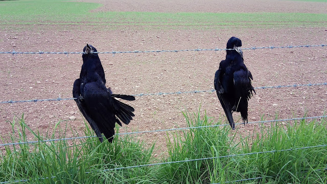
The only down side was the rather macabre and IMO pointless hanging dead crows on a barbed wire fence. I know crows are intelligent, but really?
Does this intimidate them?
And, is it really necessary, or just a pointless barbaric practise?
Anyway, that aside, we dropped down to the old church in Fern , where we stopped for a rest.
It's an interesting place in dip.
Whilst there, having a snack and liquid, we also had a chat with a lovely old couple, who came here once a year to tidy the grave of I think the ladies mother. Al will remember the full story.
We waved goodbye as we headed on up the road towards Fern Lodge, they waved as they drove past.
Phil and I carried on to the end of the road for a brief sit down, as Al had another gardening exercise in the woods.
Not many photos today, as it was basically road now into Brechin.
About 11km of the bloody stuff.
By the end of it my feet ached.
We had a lunch break at Careston, stopping on the concrete wall by the scenic old Telephone Exchange (it wasn't, I was being ironic)
We carried ON, and ON, and ON …………………….
Finally arriving in Brechin, we stopped at the first Pub we came to, which may have then involved beer.
Eventually, it was time to go and find the B&B.
From the outside, it looked like it wouldn't be up to much.
But oh how 1st impressions can be wrong.
The door opened and we entered into paradise.
Sorted out kit in superb rooms.
Cracking hot showers.
Washing done and cleaned and tumble dried, and other stuff hung on the line, and TV, and relaxed...
We'd go to the pub where we'd meet up with Jeff Cracknell later.
It was now time to do NOTHING for a while.
It was bloody lovely.
And yes, later on we went to the pub and had food and beer and....
Listen, we'd earned it!!
Just one more day to go, and it would all be over. 😥
Day 14 - Thu 24th Brechin to Kinnaber Links & then Montrose (17km)
Today was a day to be away reasonably early, so we went for a 7.30 breakfast.
I needed to get back to the Park by about 14.30 (ish) to sort out room, and also musical stuff with Humphrey.
And we had to get out of Brechin without crossing the 60 line.
And we were very very close to it.
In fact about as close as you can get, as we had to turn the corner before the railway, and for safety sake, we decided it was probably best to stay on the left.
 |
| The purple line is the 60 parallel The red dots are our route. |
 |
| Venture no further |
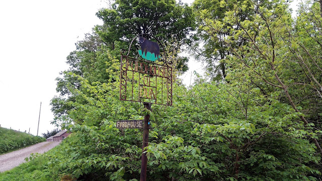
After North Dun, we followed a track past Fordhouse of Dun, and then down onto a left turn and another track towards Langley Park and Kirkhill.
Stopping for a foot rest and drink just before the wooded area to the right.
The path heading up and and over a bridge into Langley Park.
OR SO WE THOUGHT 🤔🤔
 |
Needs more hydration???
No, it's OK, it's vitamin C drink!
|
Time to head on up the track and over the bridge.
You'd hope wouldn't you?
What path?
What bridge?
Totally overgrown...
No, I mean totally!!!
We walked through the field and then had to brave the waste high overgrown boggy nettle strewn horror to the bridge.
Waist high at the lowest at times.
The the huge metal barrier at the bridge that said Danger, No Entry Do Not Cross!
The ***K we won't.
Round the barrier, and across the bridge again waist high horrors, using poles to check there wasn't a sodding great hole to hell below.
Another bloody great metal barrier to be navigated the other side where we would reach the track out.
NA!
Nettles all the way round until we finally got to the buildings.
I grabbed dock leaves to rub onto my chins where I had been stung through the trousers.
(Al spotted the excellent typo above highlighted. Too good to correct IMO)
Whoever put that on the map, has never been up it that's for sure.
End then we were past the abandoned and decaying buildings and back on the road to Hillside.
Hillside and on to Kinnaber Links via Charlton Farm.
We wouldn't stop here, beach first collecting random Challengers on route.
The most we had seen for 2 weeks.
If someone can provide a picture of me on the beach to prove I was actually there, it would be nice!
Just sayin…
Then it was back to Charlton's Farm to tea and strawberry tart, and to meet Humphrey who had driven out to chauffeur us back to civilisation.
Why? Did I not take a picture of the strawberry tart either?
And really, apart from celebrations and stuff, and getting a room in the Park, and sorting out gear, and collecting another certificate and bits and tea, and meeting folk, and chatting, and getting guitar from Humphrey, and reminding myself of songs, and setting up music stuff, and the meal and staying up until 2.30 am and having a whisky and....
Well, apart from that!
That was it.
It was all done AGAIN!
Well That's All Folks!
Obviously I'm NEVER EVER EVER EVER going to do it again.
Except next year is the 40th 🤔
And well, it would be rude not to apply, and it would be bloody lovely to get in.
So, oh yes please.
I did start the 25th, but since I broke my leg on day 2 and got air lifted out, that year turned out to be a bit of a disappointment, and I missed all the celebrations.
So YES!
The 40th!
That would be nice!
I will finish up at the end with the comment I wrote in the book this year!


