May also contain spelling and grammar errors.
I haven't checked.
Move on, it's not that important!
The music is all part of the blog post (PRESS PLAY)
Day 07 - Wed 18th May - Kingussie to SYHA Glenmore Lodge
I could have started with my breakfast at the hotel, but I needed to head off, as they didn't start breakfast until 09.00 , so I dropped the key off, said goodbye the small dog, that had forgotten who I was, and heeded out down the road towards the barracks.
It had absolutely PISSED IT down in the night, with huge puddles on the road, and looking at the large dark clouds, it looked like it might well do it again soon, but I braved the NO waterproofs on yet thing, and headed off, trying to keep off the road as much as possible, and picking up as many signs as I could for the Speyside Way, they would get me off road, all the way from the Ruthven barracks to the track to Tromie Bridge. This was deep joy, as that road walk used to be an utter ball ache.
You do have to swap sides from right to left part way along and head through some pretty little paths. The TARMAC LUVVIES would just go down the road bashing their feet in the same way every step, and thus save about ½km and at least 4 minutes 🙄🤷♂️.
Crossing the road and over the bridge at Tromie Bridge, there is an almost invisible track to the left, that climbs and cuts up through the woods, and joins the main track at a small gate, just before the buildings.
The start of the new track from Tromie Bridge, is far better than it used to be.
Once a muddy mess, it is now a big track and good surface, until you get anywhere near a farm building, where it is back to a muddy bleeding mess again.
 |
| An excellent holiday home project???? |
As good as the track is, today was a day when someone to chat to, to take the mind off the sameness of the never ending forest trails would have been good.
Instead I went over song lyrics in my head.
 |
| A bench, so SIT CLUB |
A right turn, and then a short way down, take the track to the dog leg track to the left.
Note, take the top track that is marked as a right of way.
Map 1 shows it.
Map 2, the 1:50000 shows the lower track, which takes you down to a lovely house, and some people with a spaniel, who then say, it was washed away and the track is now at the top. Happens all the time!
 |
| Correct top route to outdoors centre |
 |
| Incorrect 1:50000 lower route past the house |
Along the top route to the outdoors centre, and then follow the signposted track that goes down to the river.
 |
| Centre |
 |
| Great little route |
 |
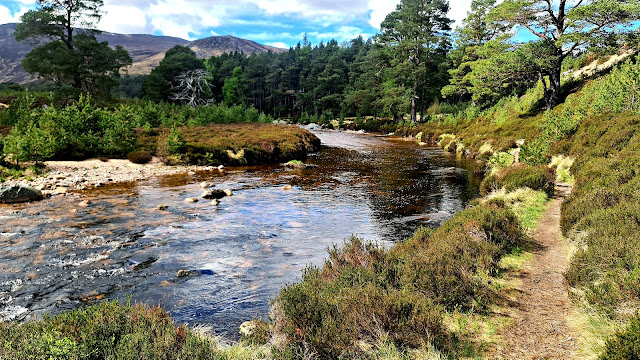
| Considering the rain, a very dry River Feshie |
This is an absolute belter of a pretty little walk all the way to Feshie Bridge.
OK, maybe not on a wet day, but even with the breeze, which could be chilly in shade, this was lovely, and today, done in just the base layer (TOP, I had the trousers on, my name isn't Boulter).
Considering how wide that river is a few kilometres earlier, it is certainly firing on all cylinders as it gets to Feshie Bridge.
NOTE:
Feshie Bridge SERIOUSLY needs a ****ing cafe, or an open bloody Pub!!
From Feshie Bridge, it is really just a bloody lot of wide forestry track, until you get to the last little strangely narrow and wet stream like ½km up to Loch Gamna.
There is a lovely little windy path by the end of the Loch, over to the other side, that then tracks a narrow path along the edge of the Loch up to cut through to Loch an Eilein.
NOW, I say a lovely windy little path.
It is and yet at places it isn't, having been mashed to F**K by bloody mountain bikes. When it gets to a wet bit, they really love to make that bit as messed up and as wide and muddy as possible, to make it an utter shitfest for anyone else.
I am officially allowed to bitch about this, because I do a lot of cycling, and in particular a lot of off road MTB cycling, but it still F***ing Pisses Me Off!
You will see in next pics, the lovely lochs, and the MTB MESS!
 |
| NUFF SAID!!!!! 🤬 |
Just past the end of Loch an Eilein, I stopped for a foot rest and to get some water from the stream, before taking the right path that heads via Lochan Deo to the Cairngorm Club Footbridge.
This used to me quite an isolated route.
Now it seems to be frequented by a lot of MTB's and E-Bikes.
The track is now easy walking, and easy cycling.
TBH, it would be bloody impossible to get lost unless you were an utter idiot, as everything is now signposted at every junction. 🙆♂️
 |
| Cairngorm Club Footbridge |
From here, it was just following signposts to Loch Morlich, and avoiding bikes TBH.
As I approached Loch Morlich, feeling bloody knackered (29 km into a warm day), I pondered on whether to just go up to the road, and then take the track in above the road. It would have been 2km shorter.
Then when I got to the decision point I thought.
"No, **** it, do the Loch south side".
So, really,(see map), I should have taken the lower nicer track over to the river to join the south path.
Still, hindsight!
The south path, is TBF, nicer than the road side walk in, but 2km longer, and rather disappointing in so far, that you rarely see the loch at all, until you get to the trails on the Eastern shoreline.
 |
| A brief LIE on a BENCH club rest near the East end of the Loch. I had arrived here just after 15.30. Feet a bit hot, they deserved a rest. AND I deserved a drink and CHOCOLATE |
Let's NOT discuss the final navigation through bits of that sprawling campsite.
It's a bloody MAZE!
But, some nice views of the Loch, until you hit the beach area, and
Dear GOD!
Bloody PEOPLE!
Anyway, to cut a LONG story short, I made it through the happy campers, got into the SYHA, and after a bit of a wait to find a human (as it was only 16.00, and normal check in time was after 17.00), I had a lovely chat with the girl working there, and got sorted in my room.
Gear organised, I then popped over to the shop opposite to see if I could buy some new undies, as this pair of Rab ones were disintegrating.
I should have known the pair I had in 2018 did exactly the same thing, and these were the free replacement.
Well, although it said gear shop, it didn't sell GEAR. 🤔🤷♂️
But, as Marty & Mer Smits were there, along with Martha's friend Mark and a couple of others, it would have been rude not to have a beer and a chat.
After which, I headed back to the YHA, to try and sort out washing and stuff, and unpack my supply parcel, and maybe, just maybe have another beer?
OK, I had already bought that on the way in! 😬🤷♂️🍻
There didn't appear to be any other Challengers at the hostel tonight, or if there were, they didn't look like Challengers, so after a good rest in the room, I headed down to the restaurant area where I had a very fine VEGGIE BURGER and maybe another beer?
Then back to the room to plan for the next day, and watch a movie on the phone.
The forecast for the next day according to MWIS was cloud cover down to 900m and pretty high winds.
That kind of put the mockers on my Ben Macdui plan, so if that was the case, I decided I would go back via the forest and the Lairig Ghru .
We'd see in the morning!
Shame about the noisy tossers down the hall.
Day 08 - Thu 19th May - SYHA Glenmore Lodge to Bob Scotts
Well, it had rained in the night, and was a bit breezy.
I went down and made a coffee for breakfast, and also grabbed a bit of free cake.
Then checked on the latest forecast.
Clear Summits & winds gusting to mid 30's
Macdui was a GO!
HIT GO!!"!!!
Plan A was to take the road and track up to the ski centre, and then up the main track all the way to the summit of Ben Macdui. Then via Sron Riach down to Luibeg Burn, and Glen Luibeg to Derry Lodge, and either stop in, or camp near Bob Scotts Bothy.
I made a slight cock up near the Parking half way up the road, and ended up walking the road all the way to the ski centre rather than take the track that cut off the corner. I don't think TBH that it made much difference.
However, DEEP BLOODY JOY as when I got to the ski centre at about 09.30, the cafe was OPEN.
Well, it would have been bloody rude not to stop, and anyway, I had skipped breakfast, so a Latte and a rather fine Ginger & Carrot Cake with Icing was purchased.
I took half that cake to the summit!
As tempting as a second coffee was, I needed to head up that hill.
It is a goodly climb, and a tad breezy.
By the time I got to the first flatish bit near Miadan Creag an Leth-choin, I had overtaken all the day walkers. I'm not sure any of them were summit bound.
I was firing on all cylinders.
It was a lovely day, apart from that bloody wind.
Weirdly it was only on the next flatter stretch that I really felt the wind.
Saw 2 people coming down.
One said hello.
The second, who was with a dog.
The dog smiled.
The bloke was one of those odd people that cannot make eye contact or speak.
I'm amazed he wasn't wearing a mask!
At one brief point it even went down!
But it's not called the Cairngorm Plateau for nothing.
Ascent to the summits is often long and slow rise, with a short sharp boulder climb at the end.
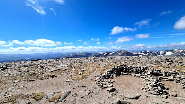
What a blinder of a set of views.
There is NO WAY that any photos do this justice or even touch on what it was really like.
CRACKER of a day so far.
For an IDEA of the wind!
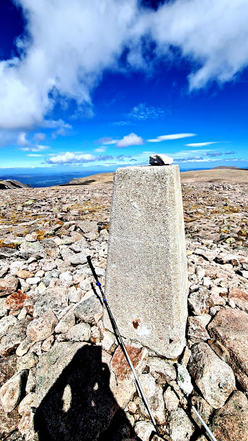
Eventually the SUMMIT at 12.08 (it's the time on the photo) and some blinding views!
Had a short stop at the top, but it was rather breezy, so it was now time to navigate off, and then find my way down and over to Sron Riach.
Best NOT to get this wrong, as to the left is a knife edge and a precipitous drop.
I ventured slightly in and dropped down and then climbed up, rather than try and walk the higher boulder route across.
I actually drifted a bit too far East near the edge before correcting, and doing the drop down to pick up a better (or less scary narrow path) back up to Sron Riach
 |
| Just off the top at 13.00 |
From here, although there is no path on the map (well, on mine anyway), there is a most definite track to follow all the way down to the glen below.
And some rather fine views too.
No more pictures until I camped.
But this is a lovely descent.
A bit wet when you hit the river near the bottom, and a couple of crossings that might be an issue in very wet conditions.
I will also say, that once you hit the bottom, it is still a ****ING long way to Derry Lodge.
Met a couple of people out with a dog who were going to camp at Derry Lodge.
And at the Lodge a chap from the US, who later I think was walking with Rita, but I cannot remember his name, although it may have been Mark.
He wasn't stopping at the lodge though, but was planning to crack on, maybe all the way to Braemar. That seemed like a sodding long day to me!
So, off I set on the final short walk round the next corner, and down to the bothy.
It was about 15.15 when I got there.
Although only just on 24 km, that was a long old walk.
I was the only one in the bothy, so I got my mat and bag out and set it up on the top sleeping area.
I may not end up as the only one here tonight, but I was claiming my spot.
A bit later on, (after 16.00) Simon Sawyers arrived.
He was going to camp outside.
I had already collected my water and had a noodle about the area.
Bloody great bothy this!
 |
| Even has a toilet |
 |
| All done and dusted and sorted by 16.00 |
That's the end of the photos.
I cooked my food, had a load of fluid, and maybe a decent snort from the whisky flask.
Actually I could really do with one now, but since I got back I've gone teetoal until August!
About 19.00, the door opened, and 4 ladies arrived.
I should remember all their names, but I cannot now.
They were off Munro bagging for the next 3 days.
One of them had a Munro Count up in the 200's.
Great bunch.
One was a chartered Surveyor, one a nurse, one in the army, and the other one I don't know.
Some good banter was had.
They had serious mountain skills.
They were concerned about snoring.
I said, just throw something at me if I do.
NO idea if I did, I was asleep.
One of them did though.
I AM hoping for more.


Great read Sir, this blog, including the expletives. Yes, May 19th was glorious, but the way bad days like Friday the 13th are remembered tells me we secretly enjoy the wet and windy stuff. I played Sonic Temple, too, great to get you through tarmac or forestry tracks.
ReplyDelete