The next 3 days are here, but have few images really for Day 04 until near the end, but there is a good anecdote from my abortive 2009 venture that I will tell.
R.L. Boyce (Jumper on the Line) [Banging Slide Guitar Babes]
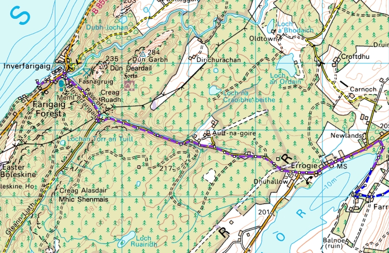
Day 04 Mon Cannich to Drumnadrochit and Loch Mhor (30.2km 762m)


So, morning start from Cannich, and then a road , then forest then road walk to Drum, where some extra supplies and a beer may or may not have been in order.
Anyway, to an anecdote from 2009 (the 2nd time I had to withdraw in medical grounds, the 1st being a broken leg).
But in 2009, I came via Tomich and then across to Drum, but for some mad reason, I came out of the woods and hot the road too early.
Also, I had sore feet having done a stupid day from Cougie to to Drum in a day 🤦♂️
So back to the anecdote.
I has walked a fair bit of road, and was sitting just inside a bus stop, tending to my feet with a rest and tape, when a small blueish car pulls up.
The window winds down, and a lovely wee old lady leans over and asks me if I want a lift to Drum.
I explain, that I would love one, but I must walk it all, as I am doing the TGOC.
We have a wee chat about it, and she drives off.
I am getting near to Drum after an extended rest, when the same car pulls over again (heading the other way).
I pop over, and the window winds down again.
"Here you are young man (I'll take that, I was 55)" and she hands me a bag of treacle toffees.
"That should get you ta where you're going"
And with a thank you and a wave, she drives off home.
Some days, you have to LOVE people 😍😁👍
And, that's exactly what I did, meeting up with some folk, grabbing a beer, and making the evening ferry across the Loch.
A couple of the following pictures are from 2007.
The ones with the nicer looking weather are 2009 , just to give a view of the Loch and the boat, as the weather in 2007 at this point was a bit blustery to say the least.


The last one is the quay at Inverfarigaig.
Now, imagine getting off there in choppy conditions, because
that IS where you climb up!
From the ferry landing, in less than ideal conditions, we took the long walk up the road, and I headed past Ault-na-Goire not knowing it was there, and all the way to the road to Farraline.
But, by now it was getting late, so sneaking into the woods by the side of
Loch Mhor, I managed to find a small enough piece of ground to pitch up.
It rained a bit, but the views as the sun set where rather spectacular.

 |
| Steve and Pete pitched up |

 |
| Rain coming in |
 |
| Tent Views |

 |
| Sunset pictures |

Day 05 Tue Loch Mhor to Coignascallen (22km 845m)


Up camp and down the road to cut through the back of Farraline, and pick up the often indistinct path over to Dunmaglass.

 |
| Approaching Dunmaglass Lodge |

All these views are now ruined by the Wind Farm (I say farm 🤦♂️)


 |
| Heading to Carn Odhar |
Choose the right route, and these are fabulous hills.
Views of wonderful plateau's and valleys, now sadly ruined by so many massive Wind factories.


Once down at the Findhorn, it is just a shortish walk along to get to the camping spot by the bridge before Coignascallan. AND YES, I did camp there last year, but I arrived this time from a different route.


Can't remember who arrived. Definitely Steve and Pete, and maybe some others.
That's my Red Laser Comp (now owned by Sandy Millar)
Day 06 Wed Coignascallen to Aviemore via the Red Bothy (24.5km 830m)


It was a nice start the next day, across the bridge and the field to then go across the grass and the river, to take the track up, and then cut ESE over open ground to take a bearing to drop down to the Red Bothy.
I love doing this bit, as really, there are no real tracks, you just need to take a bearing and look at th ground and geography
 |
| Ready to leave over the bridge, and the open grass to the river diagonally opposite |

 |
| Dropping down to the track that leads to the Red Bothy |
AND yet again, I didn't do that outlier Corbett 🤷♂️


 |
| Easy walking, but the Burma Road is an enormous scar visible for miles |

 |
| Peter nearing the top |


Now, here is the weird thing.
I assume there was food and drink in the pub that night somewhere.
I did walk up to Tesco and buy a bit of steak and a bun for the next day
(Humphrey would be proud).
BUT... I cannot for the life of me remember who else was there.
Nor, can I remember where I actually stayed 🙆♂️
I am assuming the same bunkhouse and the pub next door from the 2006 Challenge.
So. that's it.
You'll have to wait for days 7 and 8, that get me to Ballater (yes, 2 days).
Much will depend on the weather tomorrow.
If it's crap I'll write it up..
No comments:
Post a Comment